top of page

St Mary's Church, Norton Subcourse, Norfolk, UK
Annegret Hall
St Mary's Church, Norton Subcourse, Norfolk, UK
Early Australian History
MAPS RELATED TO REDFERN'S LIFE

1802 allotments on Norfolk Island.
William Redfern bought allotment A, on the road to Queenborough.

Redfern's 100 acre Sydney farm.
1840 map of Sydney with Redfern's 100 acre farm encircled in red. (SLNSW: Z/M3 811.15/1840/2)

1807 map of Sydney.
Sydney map showing the George Street hospital (A), surgeon’s houses (B), Wills property (C), St Philip’s Church (D). (NLA: MAP F 105B)

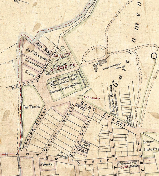
Macquarie Place properties mid 1820s
Simeon Lord's property was rented by Redfern in 1826. (HLRV: AO MAP 349)

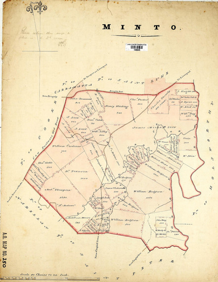
Map of Minto district showing Redfern properties
19th century Minto parish map. (HLRV: AO MAP 250)

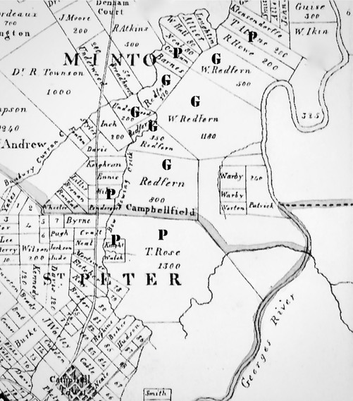
1840 map of Campbellfield.
Map showing Redfern's land grants (G) and land purchases (P). (NLA: MAP F 263)

1842 map of Edinburgh.
Encircled areas show Lothian Street, Edinburgh University College, Moray Place and his son's highschool. (NLS: EMS.X.009)

1842 map of the Sydney Redfern estate.
Map shows the first allotments sold of the Redfern estate. (Z/M3 811.174/1842/1)

1843 map of the Campbellfield estate.
Map of the Campbellfield estate showing the 112 lots offered at an auction.
(SLNSW: Z/M2 811.1134/1843/1)
(SLNSW: Z/M2 811.1134/1843/1)

1841 map of Redfern property at Cox’s River
Redfern estate in the Cox’s River district. (SLNSW: Z/M3 812.26/1841/1)

1802 allotments on Norfolk Island.
William Redfern bought allotment A, on the road to Queenborough.

Redfern's 100 acre Sydney farm.
1840 map of Sydney with Redfern's 100 acre farm encircled in red. (SLNSW: Z/M3 811.15/1840/2)

1807 map of Sydney.
Sydney map showing the George Street hospital (A), surgeon’s houses (B), Wills property (C), St Philip’s Church (D). (NLA: MAP F 105B)

Macquarie Place properties mid 1820s
Simeon Lord's property was rented by Redfern in 1826. (HLRV: AO MAP 349)

Map of Minto district showing Redfern properties
19th century Minto parish map. (HLRV: AO MAP 250)

1840 map of Campbellfield.
Map showing Redfern's land grants (G) and land purchases (P). (NLA: MAP F 263)

1842 map of Edinburgh.
Encircled areas show Lothian Street, Edinburgh University College, Moray Place and his son's highschool. (NLS: EMS.X.009)

1842 map of the Sydney Redfern estate.
Map shows the first allotments sold of the Redfern estate. (Z/M3 811.174/1842/1)

1843 map of the Campbellfield estate.
Map of the Campbellfield estate showing the 112 lots offered at an auction.
(SLNSW: Z/M2 811.1134/1843/1)
(SLNSW: Z/M2 811.1134/1843/1)

1841 map of Redfern property at Cox’s River
Redfern estate in the Cox’s River district. (SLNSW: Z/M3 812.26/1841/1)

1802 allotments on Norfolk Island.
William Redfern bought allotment A, on the road to Queenborough.

Redfern's 100 acre Sydney farm.
1840 map of Sydney with Redfern's 100 acre farm encircled in red. (SLNSW: Z/M3 811.15/1840/2)

1807 map of Sydney.
Sydney map showing the George Street hospital (A), surgeon’s houses (B), Wills property (C), St Philip’s Church (D). (NLA: MAP F 105B)

Macquarie Place properties mid 1820s
Simeon Lord's property was rented by Redfern in 1826. (HLRV: AO MAP 349)

Map of Minto district showing Redfern properties
19th century Minto parish map. (HLRV: AO MAP 250)

1840 map of Campbellfield.
Map showing Redfern's land grants (G) and land purchases (P). (NLA: MAP F 263)

1842 map of Edinburgh.
Encircled areas show Lothian Street, Edinburgh University College, Moray Place and his son's highschool. (NLS: EMS.X.009)

1842 map of the Sydney Redfern estate.
Map shows the first allotments sold of the Redfern estate. (Z/M3 811.174/1842/1)

1843 map of the Campbellfield estate.
Map of the Campbellfield estate showing the 112 lots offered at an auction.
(SLNSW: Z/M2 811.1134/1843/1)
(SLNSW: Z/M2 811.1134/1843/1)

1841 map of Redfern property at Cox’s River
Redfern estate in the Cox’s River district. (SLNSW: Z/M3 812.26/1841/1)
1/10
bottom of page